Press release by Parrot through realwire
####
Parrot Bluegrass The Multipurpose Quadcopter Solution For Agriculture
Parrot Bluegrass is the first Parrot quadcopter specifically designed for agriculture, and is the latest Business Solution from Parrot joining and complementing the Parrot Professional range. This includes the Parrot Disco-Pro AG & Parrot Bebop Pro-3D Modeling, which launched earlier this year, and more recently – Parrot Bebop-Pro Thermal.
2017 has been a significant and busy year for Parrot, with the launch of the company’s Parrot Professional range in Q2 2017. The new solutions combine Parrot’s consumer and commercial technologies and provide access to drone intelligence for small business and independent users. Just last month (September), Parrot also announced the global launch of two new additions to its consumer range – Parrot Mambo FPV and Parrot Bebop 2 Power.
With the launch of Parrot Bluegrass, Parrot is once again affirming its commitment to innovating new solutions that benefit businesses with UAVs, sensors and software that embeds a new level of precision data, and can be plugged into existing industry workflows. Parrot Business Solutions is changing the way a large number of industries work and helps to improve ROI, efficiency and productivity.
https://www.youtube.com/watch?v=MyQyp_wwpoc
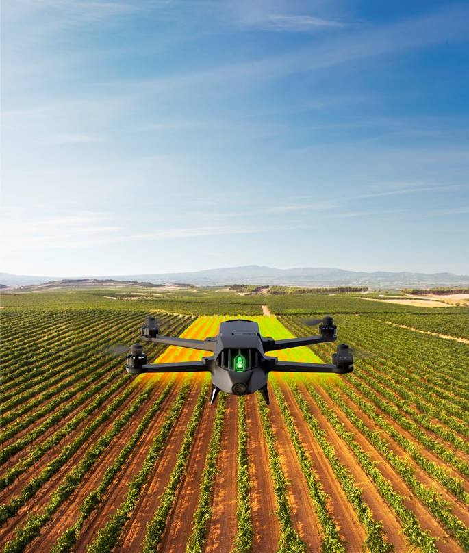
Parrot Bluegrass is a multipurpose quadcopter designed for agriculture professionals, and helps farmers improve their ROI, using its two embedded cameras; video camera and multispectral sensor. With its front Full HD video camera, this solution lets users visually monitor the farm’s infrastructure, land and herds. It also enables farmers to get a full overview and detect problem areas in all types of crop fields quickly and efficiently, thanks to its multispectral sensor designed for Precision Agriculture, Parrot Sequoia, and the easy to use processing cloud platform – AIRINOV FIRST+.
Parrot Bluegrass can automatically cover up to 30 hectares at 70 m / 230 ft. flight altitude per battery use. It can also fly at low altitudes, optimising crops that may require precise mapping.
Parrot Bluegrass is a user friendly integrated solution especially designed for farmers. It is easy to set up, easy to fly with its Pix4Dcapture autonomous flight capability, easy to process data with AIRINOV FIRST+, and easy to maintain and repair.
Parrot Bluegrass Agricultural Solution includes:
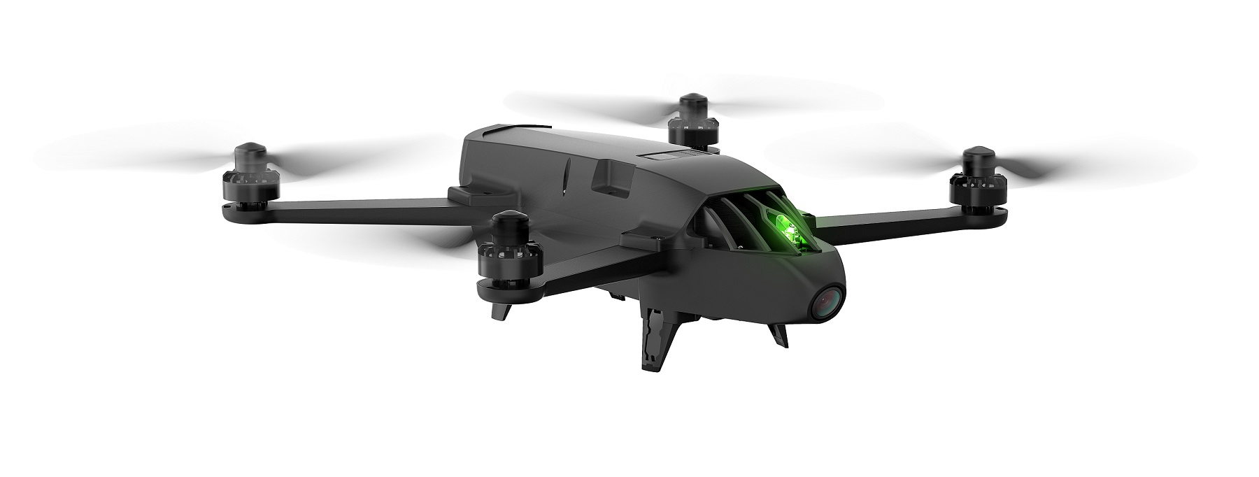
· A powerful and easy to handle quadcopter equipped with a full HD front camera and embedded Parrot Sequoia advanced multispectral sensor.
· Flight planning mobile application with Pix4Dcapture
· Data processing with AIRINOV FIRST+ cloud platform
· A long range remote control Parrot Skycontroller 2
Parrot Bluegrass: The quadcopter designed for agriculture
· Precision Agriculture
Parrot Bluegrass is a robust quadcopter weighing just 1.9 kg. It is fully-equipped with a powerful, on-board computing system, as well as embedding the Parrot Sequoia – an advanced multispectral sensor for Precision Agricultural solutions facilitating crop analysis.
· Autonomous flight and mapping
Parrot Bluegrass includes Pix4Dcapture, the world’s first planning app that enables farmers to precisely define the specific plot they want to map.
The user adapts the flight parameters according to the precision needed and the type of crops.
The entire flight, from take-off to landing[1], is automated by the quadcopter and the images captured by its frontal Full HD 14MP camera are streamed live on the screen of a connected tablet.
· Manual observation flight
As a multipurpose tool, Parrot Bluegrass can also be piloted manually using the included Parrot Skycontroller 2 Wi-Fi remote control, which provides a 2km range, with the capability to statically hover and inspect
The solution lets farmers observe their crops from new heights and capture video footage of their land, infrastructure or livestock thanks to the drone’s HD frontal camera. Users can also inspect areas that are invisible at eye-level, identify suffering parcels or potential issues that are often missed on the ground.
Parrot Sequoia, a miniaturized multispectral solution made for drones
Parrot Sequoia embedded in Parrot Bluegrass provides a complete and accurate multispectral imagery solution for drones that captures images of crops in both visible and invisible spectrums.
The solution consists of:
· A multispectral sensor with GPS, that automatically records images of crops in four distinct spectral bands: green (500nm Bandwidth 40nm), red (660nm Bandwidth 40nm), red-Edge (735nm Bandwidth 10nm) and near Infrared (790nm Bandwidth 40nm).
· A sensor equipped with a RGB camera (16 MP)
· An internal 64GB memory to store captured images
· A luminosity sensor (‘sunshine’ sensor) that detects lighting conditions and automatically calibrates collected data with the multispectral sensor data during the computer processing phase.
AIRINOV FIRST+, the mapping and analysing platform for multispectral images
AIRINOV FIRST+ online platform enables users to process and analyse the data and images captured by Parrot Sequoia.
In just a few hours, the farmer receives a turnkey report composed of orthomosaic NDVI maps (absolute and adjusted) and zoning (simple and detailed). This provides a precise view of the biomass (density of vegetation) and relative health of the crops, helping professionals to determine which areas need specific attention. Professionals can use these insights to understand which areas require the most maintenance and track the effects and evolution of the farm with high precision.
With Parrot Bluegrass, farmers and agriculture cooperatives keep the control of the data captured by the quadcopter and the analysis of these data is directly delivered to them, with no intermediary.
Who is the Parrot Bluegrass designed for?
Parrot Bluegrass is a multi-purpose business solution to help agriculture and horticulture professionals, farmers and independents make informed decisions.
With the embedded Parrot Sequoia advanced multispectral sensor enables Precision Agriculture mapping and data analysis of crops, combined with Parrot Bluegrass’s ability to fly at low altitude gives optimization for fruit crops.
Its front camera, together with the possibility to do static flights, facilitate the observation of livestock or specific areas of land or terrain.
Parrot Bluegrass will be available in November 2017 at drone resellers, farming outlets, agricultural technology specialists and www.parrot.com
MAP: £4.500ex VAT
Parrot Bluegrass pack content:
· 1 Parrot Bluegrass quadcopter
· 1 Parrot Sequoia
· 1 Parrot Skycontroller 2
· 1 Backpack
· 3 Batteries Lithium Polymer (25min per battery)
· 2 Chargers
· 1 Year license to AIRINOV FIRST+
· 1 Month access to Pix4Dag
[1]Please check local regulations before flying.
About Parrot Drones
Parrot Drones is a subsidiary of Parrot, founded in 1994 by Henri Seydoux.
Parrot creates, develops and markets advanced technology wireless products for consumers and professionals. The company builds on a common technological expertise to innovate and develop in three primary markets:
· Civil drones: With recreational drones and solutions for professional use.
· Connected objects: With a focus on audio and gardening.
· Automotive: With the most extensive range of hands-free communication and infotainment systems for vehicles on the market.
Headquartered in Paris, Parrot currently employs more than 700 people worldwide and generates the majority of its sales overseas.
Parrot has been listed on Euronext Paris since 2006. (FR0004038263 – PARRO)
For more information, please visit www.parrot.com
Stay tuned on the Personal Drones Blog for the latest quadcopter and multirotor news!